Drone Regulations

Drones provide a magical view of the world from above, yet the joys of flight must be coupled with adherence to both FAA and US Forest Service drone regulations related to the Rollins Pass area.

The Rollins Pass (Corona Pass) Road Status page as well as the Rollins Pass Maps page provide information on where motorized vehicles can and cannot drive on the pass and what current conditions look like. This page is similar: it provides information on flying drones on/near the Rollins Pass area in Colorado. While it may not be updated as often as the road status page, it does provide direct links to official content that are always up-to-date. Drones or unmanned aerial systems (UAS) provide a magical view of the world from above, yet the joys of flight and flying a drone need to be coupled with adherence to regulations set forth by both the US Forest Service (USFS) and the Federal Aviation Administration (FAA). The guidance provided below comes from multiple sources, including the USFS and the FAA and apply to all drones, regardless of size or weight, under 55 pounds. While thorough, this page is not meant to be comprehensive, and you should always consult all official sources before launching your drone anywhere in the United States.

⚠️ Regardless of where you fly, remember the FAA regulates airspace from the ground up. This means, if you’re flying outdoors no matter how low or how far away you are from a city or airport, you must understand and comply with airspace requirements. ⚠️

If you’re piloting a manned aircraft over the mountains, review the resources on our Mountain Flying page.

Pro Tip: While drones have advanced cameras and amazing flight capabilities, they also have significant drawbacks: no situational awareness of active incidents such as nearby TFRs, wildfires, and wilderness boundaries.

Do not rely on your drone to tell you if you are allowed to fly at a particular location or in a specific area. Merely having updated drone firmware and connecting via the handheld controller and/or your cellphone does not automatically grant you permission to fly in a particular location. Many people mistakenly assume that if the propellers start spinning and the drone takes off, it’s automatically permissible to fly there—this is incorrect as well as potentially unsafe. Even if the drone software indicates ‘Recommended Zone’ (or similar designation), the drone software lacks the ability to consider real-time developments like breaking news, VIP movements, wildfires, and other dynamic restrictions that can undergo changes on a daily or even hourly basis. (As of January 13, 2025, DJI drones no longer enforce geofencing. Instead, regulatory compliance is now entirely the responsibility of the operator, emphasizing the principle that operators are ultimately accountable for adhering to all applicable regulations.) For example, did you know that if there is a 30 nautical mile TFR established over the City of Boulder, Colorado that you cannot fly your drone anywhere on Rollins Pass or even in Winter Park or Fraser?

So what should you do? How do you know if both the location and airspace are good so that you can fly confidently?

Use Aloft Air Control (available for iOS, Android, as well as a stand-alone web application) or the Air Aware app (iOS, Android, or web app) before taking off to ensure the airspace isn’t closed by a TFR, wilderness, or for other reasons. It is your responsibility to safely and compliantly fly your drone for the benefit of continued access with drones in the national airspace.

KNOW WHAT YOU NEED

In the event you are “ramp checked” by law enforcement or by an aviation safety inspector from the FAA, you will need your valid driver’s license (or valid State ID), Remote Pilot certificate (and have proof of a recurrent exam within the past 24 months) or the TRUST certificate if flying recreationally, your aircraft’s registration printout, any airspace authorizations and/or waivers, including any OOP or BVLOS paperwork. All documents must be physical—not electronic—and must be “readily available” per John Meehan, FAA Aviation Safety Analyst. Your UAS will also need to be displaying its FAA registration number on the outside of the drone. The drone will also need either an external Remote ID broadcast module or broadcasting standard Remote ID as there are no FRIAs on or near Rollins Pass. Also having a preflight checklist is a good idea to prove compliance with §107.15. Drone Questions? Contact the FAA UAS Support Center at: 844-FLY-MY-UA.

Drone Questions? Contact the FAA UAS Support Center at: 844-FLY-MY-UA

INFORMATION ON REMOTE ID

Operators who do not comply with Remote ID could face fines and suspension or revocation of their drone pilot certificates.

Remote ID applies to drones which are required to be registered or have been registered with the FAA, including those flown for recreation, business, or public safety, and drones that are foreign-registered.

Why is Remote ID necessary?
Remote ID is necessary to ensure the safety and security of the national airspace system by distinguishing compliant airspace users from those potentially posing a safety or security risk. Remote ID also helps to lay the foundation for routine advanced operations such as package delivery and flying beyond visual line of sight.

What do I need to do?
There are three ways to comply with Remote ID:
1. Operate a Standard Remote ID Drone—a drone produced with built-in Remote ID broadcast capabilities; or
2. Operate a Drone with a Remote ID Broadcast Module—a device with Remote ID broadcast capabilities that can be attached to a drone; or
3. Operate at an FAA-Recognized Identification Area (FRIA)—areas where drones without Remote ID broadcast capabilities can operate.

How do I know if my drone or broadcast module is Remote ID compliant?
1. Go to the FAA UAS Declaration of Compliance website
2. Click on “View Public DOC List”
3. Filter by “RID” and “Accepted”
4. Search for your drone or broadcast module

My FAA-registered drone or broadcast module broadcasts Remote ID but is not on the Public DOC List, am I Remote ID compliant?
No, even if advertised as “Remote ID ready” or uses other verbiage, only drones or broadcast modules listed on the FAA DOC are in compliance with the rule.

Do I need to update my drone’s registration with Remote ID information?
If your drone or broadcast module is listed on the public DOC list, you need to register or update your existing drone registration through FAADroneZone to include the standard Remote ID drone or Remote ID broadcast module serial number. The Remote ID serial number is not the same as your drone’s serial number. Drone owners should check with their manufacturer for additional information.

Since recreational pilots only need to register once and can apply that registration number to multiple aircraft, they can list one Remote ID broadcast module serial number and move the broadcast module from drone to drone as long as it is listed on the same registration.

Part 107 pilots need to register each drone individually. Therefore, each drone must have its own Standard Remote ID or Remote ID broadcast module serial number.

Visit the FAA’s Remote ID webpage to learn more about adding a Remote ID serial number to your drone’s registration.

KNOW THE SAFETY RULES FOR RECREATIONAL FLYERS

Please note that this list is not comprehensive, as it focuses specifically on areas in and around Rollins Pass. As such, you won’t find rules about flying near sporting events or stadiums, since none exist on Rollins Pass. Additionally, different airspace classifications are not relevant to this area, so they have been excluded from the safety summary below, along with other considerations that don’t apply to this unique environment. However, anyone flying a drone in the U.S. National Airspace System (NAS) is responsible for adhering to FAA guidelines and regulations, meaning it is up to you as a drone pilot to know the rules.

  • Fly only for recreational purposes: Your drone should be used purely for enjoyment and hobby, not for commercial activities. The FAA clarifies that non-recreational drone flying extends beyond obvious commercial purposes. Many assume that recreational flying simply means you’re not being compensated, but that’s not always the case. For instance, taking photos or videos with the intent to later sell or monetize them, even in remote areas like Rollins Pass, is considered commercial use, regardless of whether you’re paid for the flight itself. Additionally, commercial use includes goodwill efforts like volunteering your drone services for a non-profit, which also requires a Part 107 certificate.
  • Fly at or below 400 feet in uncontrolled (Class G) airspace: Keep your drone within this altitude to remain compliant. Remember, the 400-foot limit applies to height above ground level (AGL), not above trees or other obstacles, even if your drone’s software permits higher altitudes.
  • Keep your drone within visual line of sight: You must be able to see your drone at all times without aids like binoculars, or use a visual observer who is co-located (physically next to) and in direct communication with you.
  • Do not fly near other aircraft: Always give way to each and every manned aircraft, including helicopters.
  • Stay away from emergency response activities: Avoid flying over wildfires, disaster response areas, or accident sites. More on this in the section below.
  • Do not fly over people or moving vehicles: Flying directly over a person, crowds, or vehicles is prohibited.
  • Fly only one drone at a time: You are not permitted to control more than one drone simultaneously.
  • Do not fly under the influence: It is illegal to fly your drone while impaired by alcohol or drugs.
  • Night Flying: You are allowed to fly at night, but your drone must have anti-collision lights visible for at least 3 miles. While some drones come with built-in lights, you will likely need to purchase aftermarket strobe lights.
  • Stay under 100 mph: Drones must not exceed a speed of 100 mph (87 knots).
  • Do not fly when it’s foggy or through clouds: Flying a drone through clouds not only violates FAA regulations by breaking the visual line of sight (VLOS) requirement, but it also introduces unnecessary risks. Moisture and electronics don’t mix well, and flying into clouds exposes your drone to moisture that could lead to serious malfunctions. Additionally, if you fly in fog under the 44809 recreational rules, you’re violating the VLOS requirement, which means you’re also violating 44809. Once you break these rules, the flight automatically falls under Part 107 regulations, where violations can carry heavier penalties, including fines. Staying compliant with VLOS helps you avoid these risks and ensures your flights remain safe and legal.

Do not operate your drone in a manner that endangers the safety of the national airspace system. Individuals violating any of these rules, and/or operating in a dangerous manner, may be subject to FAA enforcement action.

KNOW IF AND WHERE YOU CAN FLY

DRONE LAWS IN COLORADO

We recommend viewing this crowd-sourced page on Pilot Institute.

DRONES, DRONE RULES, & DRONE USE NEAR ROLLINSVILLE, COLORADO

At present, the area near Rollinsville, Colorado is Class G airspace and has no military bases designated as Department of Defense facilities, national landmarks (Statue of Liberty, Hoover Dam, Mt. Rushmore), or certain critical infrastructure (nuclear power plants). However, please be mindful of several nearby wilderness areas—read more on wilderness further below on this page.

DRONES, DRONE RULES, & DRONE USE NEAR WINTER PARK, COLORADO

At present, the area near Winter Park, Colorado is Class G airspace and has no military bases designated as Department of Defense facilities, national landmarks (Statue of Liberty, Hoover Dam, Mt. Rushmore), or certain critical infrastructure (nuclear power plants). However, please be mindful of several nearby wilderness areas—read more on wilderness further below on this page. Additionally, Winter Park Resort prohibits the operation of personal drones on or above its property; this policy applies to all guests, including recreational users (hobbyists) as well as Part 107 pilots.

FAA UAS DATA

Click here for a map of FAA UAS Data and information on getting started with drones.

MINIMIZING WILDLIFE INTERACTIONS AND A REMINDER THAT DRONES CANNOT BE USED FOR HUNTING

Wildlife can be easily spooked by a drone. Remember, if an animal notices the drone and/or changes its behavior, your drone is too close.

Colorado Parks & Wildlife (CPW) Field Services Assistant Director Heather Dugan said the use of a drone for hunting is not only a violation of CPW Commission Regulations, but also a violation of the Federal Airborne Hunting Act. “The bottom line is, if it’s related to a hunt in any way, you can’t do it. For scouting, locating, anything. If they fly before they take an animal, they’re illegal. If they use the drone to locate an animal they may have shot and wounded, they’re illegal. If we can prove they used a drone to locate wildlife and then killed it, it would be an illegal possession of that animal. That could be a fine of up to $125,000. It just depends on the circumstances and range of what they’re doing.”

TFR

Never fly your UAS over or in close proximity to any fire operation (wildfire or prescribed/controlled burn). UAS flights over fire operations disrupt aerial firefighting operations and create hazardous situations. In fact, unauthorized UAS flights could lead fire managers and incident commanders to suspend aerial wildfire suppression operations until the UAS has left the airspace and they are confident it won’t return. Suspending air operations could decrease the effectiveness of wildfire suppression operations; the effects of the lost aircraft airtime could be compounded by potential flames moving into untreated terrain. This delay could allow wildfires to grow larger with the potential to threaten lives and property. Suspended air operations could also delay transportation of firefighters to different locations and add to costs of fighting the fire. If you see smoke, assume that a Temporary Flight Restriction (TFR) is already in place.

Most TFRs in the Rollins Pass area are for to provide a safe airspace for firefighting aircraft. Firefighting aircraft need a safe environment that extends well past the edges of a wildfire. Do not fly drones within a TFR: this means no recreational, commercial, real estate, or any other drone-related activities. Let these pros do their jobs without any interference from drones. If you fly, they can’t.

To emphasize the significant air resources that can be deployed on a wildfire smaller than 3,000 acres, consider the example of the Alexander Mountain Fire near Loveland, Colorado on July 30, 2024. This fire required substantial aerial support: “2 air attack planes, 4 large tankers, 4 single engine air tankers, 1 very large air tanker, 1 lead plane, and 5 helicopters.” Additionally, a Multi-Mission Aircraft was used to map the fire. Very Large Air Tankers (VLATs), such as DC-10 aircraft, operate at an altitude of 200-250 feet above the ground and are less maneuverable due to their size. In contrast, smaller and more agile planes fly at altitudes of just 100-150 feet above the ground, allowing them to navigate more easily and precisely. The presence of a drone, regardless of its size, can immediately ground all of these professional and highly-skilled resources, leading to the loss of valuable time, which may result in the destruction of structures and potentially loss of lives. Furthermore, if a drone were to collide with one of these aircraft, it would directly endanger the more than 270 firefighters and emergency personnel battling this fire on the ground. Please remember the use of unauthorized, unmanned aerial systems (UAS), or drones, in a fire area endangers the lives of pilots and firefighters. Never fly uncrewed aircraft over or near a fire.

FLIGHT RESTRICTIONS ENFORCEMENT

After a drone struck the wing of a firefighting aircraft during the Los Angeles wildfires of January 2025, the FAA issued the following statement (in italics): It’s a federal crime, punishable by up to 12 months in prison, to interfere with firefighting efforts on public lands. Additionally, the FAA can impose a civil penalty of up to $75,000 against any drone pilot who interferes with wildfire suppression, law enforcement or emergency response operations when temporary flight restrictions (TFRs) are in place. The FAA treats these violations seriously and immediately considers swift enforcement action for these offenses. The FAA has not authorized anyone unaffiliated with the Los Angeles firefighting operations to fly drones in the TFRs.

Flying a drone near a wildfire is dangerous and can cost lives. When people fly drones near wildfires, fire response agencies often ground their aircraft to avoid the potential for a midair collision. Delaying airborne response poses a threat to firefighters on the ground, residents, and property in nearby communities, and it can allow wildfires to grow larger.

The FAA has implemented several Temporary Flight Restrictions (TFRs) in the Los Angeles area to protect firefighting aircraft. All other aircraft, including drones, are prohibited from flying in TFRs unless they receive authorization. 

Listen to our [the FAA’s] podcast about wildfires and aviation.

If you fly, we can't! Drones near wildfires are not safe!

If you fly, they can’t—please avoid any TFRs whether by manned or unmanned aircraft. Leave your drone at home!

The video shows a firefighting aircraft flying ‘nap of the earth’ to combat a wildfire. Pilots cannot be on the lookout for drones while concentrating on fire suppression efforts, which is why flying drones anywhere near these operations is strictly prohibited.

KNOW WHERE YOU CANNOT FLY

WILDERNESS

Rollins Pass is sandwiched between two congressionally designated wilderness areas: the Indian Peaks Wilderness, created in 1978, and the James Peak Wilderness, established in 2002. The Indian Peaks Wilderness is located north of the James Peak Wilderness.

Below is a map (north is up), from Aloft Air Control, showing wilderness areas shaded with light red (please note for different apps or in different versions of apps, the red may be a different color—the end result remains the same). Per the US Forest Service (USFS), “UAS are considered to be both ‘motorized equipment’ and ‘mechanical transport’ and, as such, they cannot take off from, land in, or be operated from congressionally designated wilderness areas.”
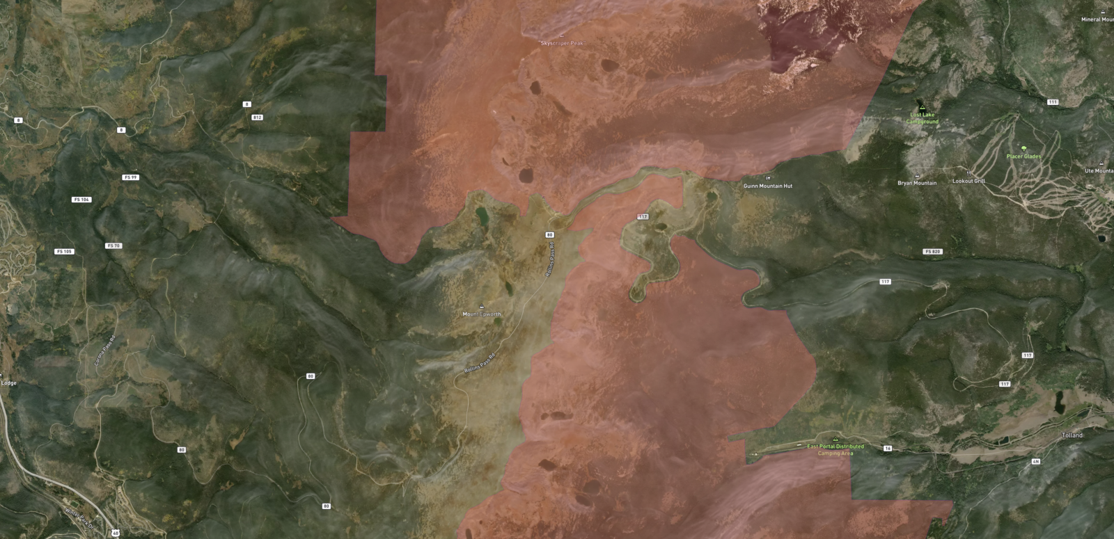
Rollins Pass is sandwiched between two congressionally designated wilderness areas: the Indian Peaks Wilderness, created in 1978, and the James Peak Wilderness, established in 2002. The Indian Peaks Wilderness is located north of the pass; the James Peak Wilderness is south of the pass.
Congressionally-designated wilderness areas are shaded in light red. The James Peak Wilderness is located south of the Indian Peaks Wilderness. North is up. (Please note: for different apps or in different versions of apps, the ‘light red’ may be a different color—the end result remains the same: UAS cannot take off from, land in, or be operated from congressionally designated wilderness areas.)

STAY ALERT FOR AIRCRAFT UTILIZING ROLLINS PASS AS A LOW CROSSING POINT ON THE CONTINENTAL DIVIDE AND YIELD TO AND AVOID ALL MANNED AIRCRAFT

Despite the airspace covering the Rollins Pass area being Class G, fast-moving military jets, low-flying military and search-and-rescue helicopters, medevac flights, as well as general aviation airplanes transit and travel near and over Rollins Pass as it is a low crossing point along the Continental Divide. It is always imperative to follow the rules to look, listen, and yield to manned aircraft. In our experience of hiking on the pass, some aircraft fly well below 500 feet AGL (above ground level) and helicopters can land along and on the pass as part of carrying out search and rescue (SAR) missions. Firefighting helicopters can also scoop or siphon water from nearby lakes.

A high-pressure natural gas pipeline traverses the montane, subalpine, and alpine landscapes of Rollins Pass, weaving through diverse ecosystems that range from dense forests to open meadows and rocky terrain. This vital piece of infrastructure supports the region’s energy network while blending into the rugged environment. Pipeline patrol helicopters equipped with gas detection systems, such as aerial laser methane assessment (ALMA) technology, play a critical role in monitoring the integrity of pipelines. These helicopters typically operate at low altitudes, often between 200 and 330 feet, to effectively detect leaks and assess pipeline conditions. In some cases, particularly in areas with dense vegetation or challenging terrain, patrol helicopters may fly below treetop levels to ensure thorough inspections. Drone pilots operating near pipeline corridors should remain aware of this unique aerial activity and maintain safe distances to avoid interfering with these essential low-altitude patrols. Always check for temporary flight restrictions (TFRs) if flying near active inspection zones to ensure safety and compliance with regulations.

Regardless of where you fly, remember the FAA regulates airspace from the ground up. This means, if you’re flying outdoors no matter how low or how far away you are from a city or airport, you must understand and comply with airspace requirements.

BE MINDFUL OF UNPREDICTABLE AND FAST-MOVING WINDS ON/NEAR ROLLINS PASS

Railroad workers more than a century ago consistently mentioned high winds on Rollins Pass. While winds at the surface may be calm, winds 200 feet off the ground can reach 93+ MPH. If you receive high wind alerts while flying, know these strong gusts exist.

TRAVELING CROSS-COUNTRY WITH YOUR DRONE?

If you’re planning a cross-country trip with your drone and intend to visit other Colorado landmarks, like Rocky Mountain National Park, it’s important to know that drones are banned in the park, and violations can lead to fines of up to $5,000.

INJURIES & DAMAGE REPORTING

Drone operators must prioritize safety at all times to avoid causing harm to people, wildlife, or property. Under FAA regulations, any incident involving a drone that results in serious injury or property damage exceeding $500 must be reported to the FAA within 10 days. This rule applies to both recreational (hobbyist) and commercial drone operators.

DO NOT SHOOT AT DRONES

The FAA has made it clear that shooting at any aircraft, including unmanned drones, is illegal under federal law and can result in civil penalties as well as criminal charges from federal, state, or local authorities. Such actions are especially troubling given that drones often play vital roles in emergency services, including firefighting, search-and-rescue operations, and law enforcement. Drones can also be used for monitoring forest health and wildlife research, mapping and surveying, as well as infrastructure inspections. Drones flying overhead on/near Rollins Pass are almost certainly focused on capturing the breathtaking scenery, not on what’s happening at your campsite.

RESOURCES, DRONE REGULATIONS, AND FOR MORE INFORMATION CONTACT THE FAA SAFETY TEAM

Drone pilots must have passed their TRUST test (The Recreational UAS Safety Test) or hold a Part 107 certificate (and, if applicable, have proof of a recurrent exam within the past 24 months.)

USFS Tips for Responsible Recreational Use of Unmanned Aircraft Systems (UAS) on National Forest Systems Lands

Learn more about drones, drone regulations, registration requirements, Remote ID, and much more from the FAA

"... The ultimate goal of regulation is that industry protect itself from negative consequence of liable operation. You [Travis] obviously understand this and are acting as a great ambassador to your community."

—FAA's Denver FSDO Office

The primary purpose of our work is to inform the public.
Preserve Rollins Pass background image