Rollins Pass Maps
Satellite maps, wilderness campfire maps, USFS Snowmobile Use Maps, as well as USFS Motor Vehicle Use Maps for both sides of Rollins Pass (Corona Pass) are provided to inform the public.
Looking for details on what the road looks like for the season? Check out our Rollins Pass Road Status page.
SATELLITE IMAGERY OF ROLLINS PASS (CORONA PASS)
The satellite map of Rollins Pass, below, begins centered at the summit of the pass at the historic townsite of Corona, located at 11,676 feet above sea level. While the entire pass is open as a thoroughfare for non-motorized travel, the parking lot at the summit (located in Boulder County) can only be reached by motor vehicles from the Grand County side of Rollins Pass, starting near Winter Park. The summit can only be reached from the east side of the pass by non-motorized means. Please note that the satellite imagery does not always display road closures/hazards nor does it always adequately represent that the pass is closed as a motorized thoroughfare across the Continental Divide. Before heading out, always print or download US Forest Service Motor Vehicle Use Maps (MVUMs). Per Stay the Trail Colorado, MVUMs are the legal trails you can recreate on—anything off that is out-of-bounds. Please abide by these limitations for the benefit of our continued access.
Many phone and tablet browsers will not display embedded PDFs; please click the ‘Download‘ button to view each PDF.
WHAT ARE MOTOR VEHICLE USE MAPS (MVUMs)?
Per the US Forest Service, “the Motor Vehicle Use Map is a requirement of the Travel Management Rule and reflects travel management plan decisions. The MVUM displays National Forest System (NFS) roads, trails, and areas that are designated open to motor vehicle travel. The MVUM also displays allowed uses by vehicle class (highway-legal vehicles, vehicles less than or equal to 50 inches wide, and motorcycles), seasonal allowances and provides information on other travel rules and regulations. Routes (includes both roads and trails) not shown on a MVUM are not open to public motor vehicle travel. Routes designated for motor vehicle use may not always be signed on the ground but will be identified on the MVUM. It is the public’s responsibility to reference the MVUM to determine which routes are designated for motor vehicle use. The MVUM may be updated annually [in January] to reflect new travel decisions and to correct mapping discrepancies. The MVUM is a black and white map with no topographic features. It is not a stand alone map and is best used in conjunction with a National Forest Visitor Map or other topographic map.”
ROLLINS PASS WEST (CORONA PASS WEST): MOTOR VEHICLE USE MAP (MVUM)
Since Sunday, July 15, 1990, no motorized route connects across the Continental Divide. Per Stay the Trail Colorado, MVUMs are the legal trails you can recreate on—anything off that is out-of-bounds. Please abide by these limitations for the benefit of our continued access. US Forest Service MVUMs also show where seasonal dispersed camping is allowed on Rollins Pass and on what side(s) of the road camping is allowed. If the map below of the west side of Rollins Pass doesn’t load, click here to load the map in a new tab.
ROLLINS PASS EAST (CORONA PASS EAST): MOTOR VEHICLE USE MAP (MVUM)
Since Sunday, July 15, 1990, no motorized route connects across the Continental Divide. Per Stay the Trail Colorado, MVUMs are the legal trails you can recreate on—anything off that is out-of-bounds. Please abide by these limitations for the benefit of our continued access. US Forest Service MVUMs also show where seasonal dispersed camping is allowed on Rollins Pass and on what side(s) of the road camping is allowed. If the map below of the east side of Rollins Pass doesn’t load, click here to load the map in a new tab.
ROLLINS PASS WEST (CORONA PASS WEST): SNOWMOBILE USE MAP (SUM)
No snowmobile route connects across the Continental Divide. Per Stay the Trail Colorado, MVUMs are the legal trails and areas you can recreate on—anything off that is out-of-bounds. Please abide by these limitations for the benefit of our continued access. US Forest Service SUMs also show where wilderness boundaries exist. If the snowmobile map below of the west side of Rollins Pass doesn’t load, click here to load the map in a new tab.
INDIAN PEAKS WILDERNESS AREA & WILDERNESS CAMPFIRE RESTRICTIONS
Campfires are always prohibited in the James Peak Wilderness per this US Forest Service page. Campfires are also prohibited in the Indian Peaks Wilderness on/near Rollins Pass by King Lake, Betty Lake, Bob Lake, Buttermilk Falls, Skyscraper Reservoir, Woodland Lake, and along the South Fork of the Middle Boulder Creek—these areas are in the Woodland BZ and Middle Boulder BZ where campfires are prohibited per this US Forest Service map; the only exception is on the ridge west of the Continental Divide (above Corona Lake), known as the Columbine Backcountry Zone (BZ). If the map below of the Indian Peaks Wilderness Area doesn’t load, click here to load the map in a new tab.
WILDERNESS AREAS
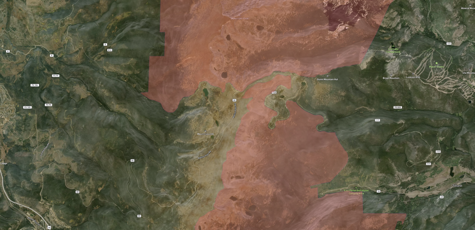
Rollins Pass is sandwiched between two congressionally designated wilderness areas: the Indian Peaks Wilderness, created in 1978, and the James Peak Wilderness, established in 2002. The Indian Peaks Wilderness is located north of the James Peak Wilderness.
Below is a map (north is up), from Aloft Air Control, showing wilderness areas shaded with light red. Per the USFS, “UAS [drones] are considered to be both ‘motorized equipment’ and ‘mechanical transport’ and, as such, they cannot take off from, land in, or be operated from congressionally designated wilderness areas.” Read more on drones here.
Vehicles of any type, including motorbikes or bicycles, cannot travel into the wilderness. The only exception are wheelchairs.

The primary purpose of our work is to inform the public.

